Places: Skeleton Canyon, Douglas, Arizona
On September 4, 1886, the Apaches who'd followed Geronimo for so many years and battles faced the worst day of their lives. They surrendered their arms to General Nelson A. Miles of the United States Army, hoping to be sent back to San Carlos. Instead, they were taken by train first to Fort Marion in Florida, and later to Alabama and even Oklahoma. Most of them never saw Arizona again. Fittingly, the place where this happened was known as Skeleton Canyon, or ironically, as Canon Bonita in Spanish, though the Apaches would have found nothing pretty about it.
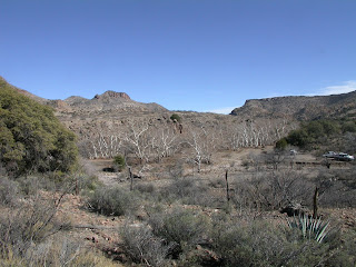
Skeleton Canyon lies 30 miles northeast of what is now Douglas, Arizona, in the Peloncillo Mountains which straddle the border between modern Arizona and New Mexico. The Canyon is the portal for the Animas Valley of New Mexico, and the San Simon Valley of Arizona. Because of its connection to these valleys and proximity to Mexico, it was a common conduit for cattle rustlers, outlaws, and the occasional honest drovers or traders. The area is rugged, with little water and a lot of sun. Animals and humans can easily break down, and in the years before modern transportation and air conditioning, death on the trail was the most likely outcome. A lot of skeletons littered the trail, both animal and human.
Skeletons also fell here as victims of mutual violence. In 1879, a group of Cowboys attacked a group of Mexican Rurales and stole their cattle. In 1881, Curly Bill Brocius and his gang attacked and killed a group of Mexican miners transporting silver. In retaliation, Mexican Federales later attacked Newman Clanton and others as they drove cattle through Guadalupe Canyon. In 1883, Apaches killed 3 U.S. Cavalry troopers, burnt their wagons and drove off their cattle, horses and mules. In 1889 Judson White was found murdered in the Canyon. And, in 1896, a shootout occurred between another outlaw gang and a posse sent to bring them in.
Geronimo's surrender happened on the western side of the canyon, on what is now private land. A cairn marks the location. A marker on State Route 80 commemorates the event.


Comments
Post a Comment